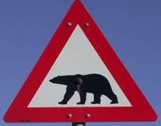
Think – where is this place? (Look at the picture below). Source: Public Domain image – http://en.wikipedia.org/wiki/File:Fareskilt_38.PNG Once you have thought about it, choose one of the colours of the placemarks on the map below. Your teacher could wait until…
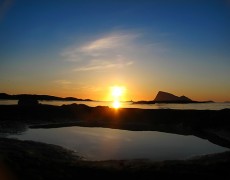
This photo was taken in Longyearbyen in Svalbard and was taken at 12.01 … in the morning. That’s one minute after midnight. Image: Some rights reserved by 0000007 And here, in a similar part of the world at a similar…
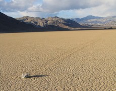
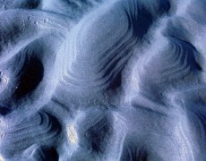
Racetrack playa from James Penstone The cards can be accessed and downloaded from here: Mystery cards “Why does Molly Move?” (PDF) The original activities, resources and ideas can be viewed on the RGS website here.
Your task (credit to Mr Potter for these instructions) You are going to select a place that you think is a fantastic place geographically. This should not be a place that you have already studied. This should make people…
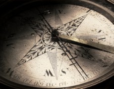
Image: Some rights reserved by mwcarruthers 1) Make sure you know the points of the compass: Easy: http://www.ngfl-cymru.org.uk/vtc/20050301/Geography/Keystage2/direction/northsout/introduct/StarterActivity.htm Easy: http://www.bbc.co.uk/scotland/education/sysm/landscapes/highlands_islands/flash/index.shtml?flash=land_ms_compass Easy: http://www.iboard.co.uk/iwb/Flight-Rescue-Compass-Directions-420 Medium– Tricky: http://mapzone.ordnancesurvey.co.uk/mapzone/PagesHomeworkHelp/mapability/compassesanddirections/ Medium: http://mapzone.ordnancesurvey.co.uk/mapzone/PagesHomeworkHelp/maptivity/compassesanddirections/ 2) Understand 4 figure grid references Medium: http://www.bbc.co.uk/scotland/education/sysm/landscapes/highlands_islands/mapskills/grid/index.shtml#focus Easy: http://bt.actis.co.uk/lds/taster_content/primary_coordinates/locate3.html 3) Put it…
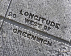
The Longitude and Latitude Song (including a karaoke session in the second half if you are feeling brave): 1) Watch this youtube clip which explains longitude and latitude very well: 2) Read through the slideshow below: Extra) Still need more?…
Part A – Ordnance Survey Map Symbols 1) Understand Map Symbols Map symbols from Noeleen geographyalltheway.com: Map Symbols from geographyalltheway.com 2) More information on map symbols A nice interactive to help you understand map symbols by mapzone, ordnancesurvey.co.uk A…
Part A – What is scale? Easy: Map Skills : Scale by BBC Medium: Understanding Scale by Ordnance Survey (pdf file) Challenging: Map Scales by USGS Part B – Measuring Distance using a map
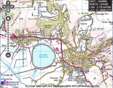 This activity needs a real OS map based on Cheddar and Weston-Super-Mare in England. Below you can see (and navigate) the same area, but the activity can’t really be done without the paper map. Here is the worksheet that accompanies…
Q. What does the word relief mean in Geography? Q. How could we show the relief of the following landscape on a map? Come up with as many ways as you can think of. Image: Mae Salong, North Thailand. Some…
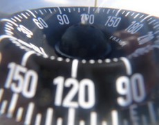
You will probably learn about bearings in Maths as well as Geography. Watch this GCSE Maths revision video – it’s really helpful. As the author of the video says, when using bearings there should be three things to have in…
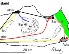
In this activity, you will work in a pair. Your aim is to create your own island. Look at the example below to get you thinking of your own ideas: Source: Image by R. Stenning You will be given an…